


clearwater lake

Bertrand Simon
Benutzer
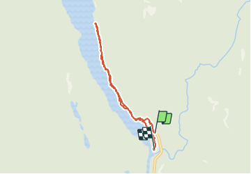

Länge
6,2 km

Maximale Höhe
717 m

Positive Höhendifferenz
118 m
Km-Effort
7,8 km

Min. Höhe
680 m

Negative Höhendifferenz
124 m
Boucle
Nein
Erstellungsdatum :
2019-08-26 16:56:44.846
Letzte Änderung :
2019-08-27 23:08:55.383
2h53
Schwierigkeit : Sehr leicht

Kostenlosegpshiking-Anwendung
 SityTrail
IGN / Geografische Institute
SityTrail World
Die Welt öffnet sich für Sie
Über SityTrail
Tour Wandern von 6,2 km verfügbar auf Britisch-Kolumbien, Thompson-Nicola Regional District, Area A (Wells Gray Country). Diese Tour wird von Bertrand Simon vorgeschlagen.
Ort
Land:
Canada
Region :
Britisch-Kolumbien
Abteilung/Provinz :
Thompson-Nicola Regional District
Kommune :
Area A (Wells Gray Country)
Standort:
Unknown
Gehen Sie:(Dec)
Gehen Sie:(UTM)
692250 ; 5780385 (10U) N.
Kommentare
Touren in der Umgebung